Many informations about COVID-19, CORONAVIRUS, how will it spread into population
in many countries, actual COVID-19, CORONAVIRUS GRAPHS, also Perspectives, forecasts, outlooks for the future, epidemic and pandemic prognosis and actual
>>>>>> COVID-19, CORONAVIRUS PREDICTIONS <<<<<<
COVID-19, CORONAVIRUS links to GRAPHS day by day
COVID-19, CORONAVIRUS links to PREDICTIONS day by day
Other interesting COVID-19, CORONAVIRUS summary links and reference pages


Crop circles
Straight lines are also
very regular patterns

Long quotations (considerably more than only a few sentences) from domain cropcirclesonline.com also translated to any language, would be better publish anywhere with author's permission. Thanks.
Also copyrighted photographs ©cropcirclesonline.com ©quick spigots
Citations allowed, certainly. Name source, please. Also link where possible, thx.
Contact cropcirclesonline@gmail.com or lightningsymbols(at)hotmail.com
If interested, contact cropcirclesonline@gmail.com
Damaged, weak and lodged plants (maybe completely died)
Over the long lines may be created in all cases in a very similar way.
Due to conducting of the electric current through the plants, their root systems and soil in their immediate surrounding, but with significant contributions of conductive pathways in the underground. They increase the electrical conductivity, mainly the soil in the vicinity and above them, up to several orders of magnitude. Such tracks can be of natural origin, archaeological or industrial. The resulting lines may be of various lengths. From less than a meter to over a kilometer. It depends on the intensity of the discharge and character of accompanying underground lines - how they contribute to the dissipation of the currents underground. On some of them (very long) may participate several discharges, or sparks of the same discharge, or any subsequent RS of the same discharge, falling in places other than the first major RS (in exceptional cases may fall to hundreds of meters apart, even further). Participates in some way a manner, which creates a conductive link between the cloud and the ground, preceding the discharge, more detailed description will be for example here.
The vast majority of them will remain for the rest of the growing season completely unnoticed. Is not impossible that they are generated in a much greater extent, than so much admired regular patterns, but they were registered only in such a case, if they were a component of some such pattern. Otherwise, they are likely to be considered as a branch of the tramline, or path in the field.
Among the most interesting long lines in the field was called Line F. L. Vek between Opocno and Dobruska. References to shorter lines are already in mainpagee. These relate primarily probable underground pipelines, water mains or sewerages. The issue will be here at this place in time elaborated in more detail, with regard to the likely archaeological and geological causes.
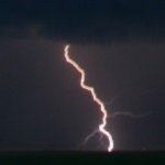
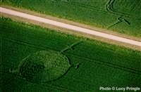
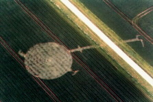
Two images in the header of this page relate to one such place, with demonstrably localised line (mentioned also in
main page). The second was captured several weeks after the first, while the far right top of the page (this paragraph left
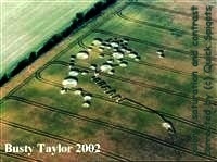
photo) is a picture of
grain "only" lodged (damaged, weakened) - but is probably completely dead. What was happening there, will be described much more detailed
for instance on the page Chronology and subpages. On the
picture under copyright (here right) is the crop completely dead and on the place was probably to find only its with difficulty
localizable and identifiable remains. The first photo is from the archive of
Lucy Pringle, the second from
busty-taylor.com. A common feature almost without exception of
all Crop Circles photos is fairly sad fact, that if they ever mentioned any date, there is only assigned to them information about
the time of the pattern discovery, (in this case, date 23, respectively 22nd May 1998). The second was taken with
probable interval at least a month from the first. No choice but politely, but also very strongly suggest to all
explorers Crop Circles, that to every professionally taken photo absolutely inseparably belongs the date of its acquisition, as
well as (or even much more) to any documentary photography acquired for purposes of scientific research. The date is for
example included in the EXIF for each image since the days, when he bought their first digital cameras (but if they ever
know what it 's EXIF). This very useful informations accompanying each photo image, unfortunately, are always during a
way from their camera to their website "mysteriously
losen". The best way for them not to do so. The informational value of of their websites would be from a professional
point of view immediately increased by thousands of percent. If the finding of EXIF information, and knowing what is it,
for them after all only unbeatable problem, would be quite sufficient the date of the photo acquire, this one most
important information would be useful to increase the benefit of their websites to world scientific progress in exactly
the same way. Of course, at least approximate GPS data are also very beneficial.
Similar cases, like they are in the header of this page, here on this site will be named the working title for now "localizable metal plate undergroundd"
Note: All own author's photographs on this site contain EXIF informations
(© cropcirclesonline.com, © quick spigots). Applies also GPS data, if contained. All photos applied from other websites have, where possible, filled in EXIF information about the source - author, website. Among other things, serves as an indication to the authors of this site, and if not immediately set up a link directly to the source, will be there certainly added sometime in the near future. In addition, it was just established (December 2011) a special page Crop Circles - GPS, where they are gradually added GPS data to the greatest number of Crop Circles photos, that have ever been found around the world, including the location of approximate shape model as closely as possible into the terrain profile (Google Earth).

Winding paths
A second case of a paths in a fields are also lines created by electricity, but in this case they are not straight at all. These are variety of tortuous paths, heading nowhere to nowhere in the field, or seemingly from somewhere to somewhere. They appear (arise) very often for several days after the discovery of patterns, and every their observer thinks therefore, that somebody tracked it out there. Paths of course, are near some patterns tracked out, but most likely by no means all of them. This may be a completely random paths, created by the excess of the electric charge, that coined the journey away from there, more or less randomly, and they are often very tortuous. In the near future here will be placed in a number of such photographs, they are dozens available. Of course, by no means all paths on them must have been made by temporarily on the ground crawling lightning discharge, some of them would be really created by some "drunken sailors ", but certainly not all of them. They may be a totally random paths, created by excess of electric charge, who tried to get away from there, more or less randomly, and are often very tortuous. Completely the same tortuous as the meanders of the lightning discharge in the air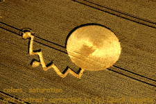
 . The
accompanying photographs in this paragraph contain several pictures of such ground paths localized directly on the
photographs Crop Circles, they are dozens of them available. Of course, not all such paths on them had to be made temporarily on the
ground crawling lightning discharge, some of them could be really created by some "drunken sailors", but certainly by no
means all of them. They may appear later after the pattern discovery (several days), that the residual discharge,
crawling away from the impact site, has no longer enough energy, and therefore plants are not affected so intensively,
as in the main pattern. Of course is not impossible even that some of such paths are after their discovery additionally
extended by the visitors of patterns, who just simply thinks, that someone had pioneered them before. Even more, that
they may not appear on the first documentary photographs recorded before, because they did not exist yet.
. The
accompanying photographs in this paragraph contain several pictures of such ground paths localized directly on the
photographs Crop Circles, they are dozens of them available. Of course, not all such paths on them had to be made temporarily on the
ground crawling lightning discharge, some of them could be really created by some "drunken sailors", but certainly by no
means all of them. They may appear later after the pattern discovery (several days), that the residual discharge,
crawling away from the impact site, has no longer enough energy, and therefore plants are not affected so intensively,
as in the main pattern. Of course is not impossible even that some of such paths are after their discovery additionally
extended by the visitors of patterns, who just simply thinks, that someone had pioneered them before. Even more, that
they may not appear on the first documentary photographs recorded before, because they did not exist yet.
 There is
possible to find one case where it is really possible that from the lightning impact site and the creation of patterns
progressed away a Ball Lighting. This will be described on some other page, especially in a place where it is explained
that the ball lightning really need not to participate on creating regular patterns, on the page where is paid attention
to ball lightnings. Of course, but it is not inconceivable that this way moved away classic discharge channel
overground. It would be quite difficult to any of the possible options to prove. It is essential that at the site in a
small height above the ground moved great electric charge. Click to enlarge, link follows the origina..
There is
possible to find one case where it is really possible that from the lightning impact site and the creation of patterns
progressed away a Ball Lighting. This will be described on some other page, especially in a place where it is explained
that the ball lightning really need not to participate on creating regular patterns, on the page where is paid attention
to ball lightnings. Of course, but it is not inconceivable that this way moved away classic discharge channel
overground. It would be quite difficult to any of the possible options to prove. It is essential that at the site in a
small height above the ground moved great electric charge. Click to enlarge, link follows the origina..
Straight lines over pipelines
 Inseparably adherent to many Crop Circles, discovered in the past, but they were left without any interest, or
remained completely unnoticed. They may pass right through the pattern, beside him, in smaller or larger distance from
it. They may be located even in relatively large distance from the pattern (several hundred meters), on a completely
different part of the field, so it may not even be considered as a part of the shape. They may occur on adjacent or even
distant field, where is not at all regularly lodged (damaged, weakened) crop, even on the field where apart from them are not already any
other lodged or dead crop at all. On the accompanying image of
this paragraph is one of the most typical lines (one other already devoted some previous paragraph). For this line is
exactly known GPS so that any doubters would the presence of the pipeline able see for themselves. Pipe passes under the
road up into the next field, which probably was not at all affected by the lightning discharge, and the electricity got
there just because of this pipeline. On the accompanying image is the part of the pipe on the second field displayed. It is
the locality Stephen Castle Down, Hampshire, 20th June 2005. GPS 50.99468 -1.20285. Click to enlarge the picture (link
to the original).
Inseparably adherent to many Crop Circles, discovered in the past, but they were left without any interest, or
remained completely unnoticed. They may pass right through the pattern, beside him, in smaller or larger distance from
it. They may be located even in relatively large distance from the pattern (several hundred meters), on a completely
different part of the field, so it may not even be considered as a part of the shape. They may occur on adjacent or even
distant field, where is not at all regularly lodged (damaged, weakened) crop, even on the field where apart from them are not already any
other lodged or dead crop at all. On the accompanying image of
this paragraph is one of the most typical lines (one other already devoted some previous paragraph). For this line is
exactly known GPS so that any doubters would the presence of the pipeline able see for themselves. Pipe passes under the
road up into the next field, which probably was not at all affected by the lightning discharge, and the electricity got
there just because of this pipeline. On the accompanying image is the part of the pipe on the second field displayed. It is
the locality Stephen Castle Down, Hampshire, 20th June 2005. GPS 50.99468 -1.20285. Click to enlarge the picture (link
to the original).
Also, because it sometimes does
not have to appear right at the same time. It may be a number of days earlier, but also later. In some (probably fairly
frequent cases) will not only grain in them be lodged (damaged, weakened), often completely dies. One of the reasons why
to them are not paid
almost any attention is the fact that the grain inside them is most probably dead so fast that it is not lodged (damaged, weakened), it dries
standing. They arise just like any commonly flattened (damaged, weakened) corn - after weakening of grain due to lightning discharges in
their vicinity. Very often receive a significantly higher dose of energy, than in the most common cases, thanks to
electrically conductive structures underground. Quite often probably occurs such a phenomenon, when the plant (its above
ground part) would the lightning hit survive with almost no damage (it is located in a relatively large distance from
the discharge), its root system but entirely was killed or received such a great dose of electricity that it's
absolutely inevitable tends to death. Her situation is rather similar to a plant, which is picked in a vase. It may also
take a little longer than there will appear the effects of discharge on it. The surrounding plants may be lodged (damaged, weakened) before it
starts to go dry. On the photo accompanying this paragraph, showing the state of barley above the underground water
pipe, which was hit by lightning (water hydrant in the background). Plants are totally killed, such a quickly that were
not able to flatten. But after a few days, there was no sign about their precedent presence.
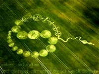
Artifacts in the underground

 It would be a mistake not to include in this page another part of the regular patterns, that alone would have been
completely not registered. Assigned a few shots where can be seen in the vicinity of patterns some unidentifiable
objects, which are attributed to a variety of magic, the cult, astrological and God knows what other graphic meanings.
Similar articles would certainly be possible to find on other Crop Circles photographs a great number. Many of them is
certainly in the absence of regular patterns left without any publicity. These are objects that lie undisturbed in the
underground for many years, and are displayed in a similar way every time in close proximity of a lightning strike (tens
of meters). It's not very often, because in high latitudes, where the figures appear, occurs annually on average to 2-3
lightning hits per km2, less than half may be outside growing season, so hit the enclosure into the field
when there is nothing more growing, and so each such object will wait to be displayed again at minimum 10-20 years or
longer, maybe 100. But as already mentioned, if there does not appear simultaneously in their vicinity a large regular
pattern,
such an event will take place entirely without any publicity. Certainly possible, that many of such visualisation appear
in proximity of any regular pattern, and
absolutely no interest results from that, and they did not fit on the vast majority of the photos.
It would be a mistake not to include in this page another part of the regular patterns, that alone would have been
completely not registered. Assigned a few shots where can be seen in the vicinity of patterns some unidentifiable
objects, which are attributed to a variety of magic, the cult, astrological and God knows what other graphic meanings.
Similar articles would certainly be possible to find on other Crop Circles photographs a great number. Many of them is
certainly in the absence of regular patterns left without any publicity. These are objects that lie undisturbed in the
underground for many years, and are displayed in a similar way every time in close proximity of a lightning strike (tens
of meters). It's not very often, because in high latitudes, where the figures appear, occurs annually on average to 2-3
lightning hits per km2, less than half may be outside growing season, so hit the enclosure into the field
when there is nothing more growing, and so each such object will wait to be displayed again at minimum 10-20 years or
longer, maybe 100. But as already mentioned, if there does not appear simultaneously in their vicinity a large regular
pattern,
such an event will take place entirely without any publicity. Certainly possible, that many of such visualisation appear
in proximity of any regular pattern, and
absolutely no interest results from that, and they did not fit on the vast majority of the photos.
 The principle of visualization is exactly the same, as in the case of underground pipe - located at a depth below
subsoil ploughing, but their presence greatly influenced the conductivity of soil near and over them, and conduction of
lightning currents in the underground thanks to them may cause a significant affecting of plants in close proximity,
mainly their root systems. This may be the archaeological artifacts, or components of agricultural machines apostated
and plowed under, also remains of any industrial activities, remains long ago abandoned water mains or sewer, or parts
of collapsed airplanes. Located at a depth below subsoil ploughing, and if no one has dig out them, they are still
there. GPS location of displayed objects are known, and those interested can go for them with a pickaxe, after
negotiating a permission from the land owner. We wish them much success in digging. Also would be possible to locate
them with metal detectors or underground radar (some of them need not be really metallic).
The principle of visualization is exactly the same, as in the case of underground pipe - located at a depth below
subsoil ploughing, but their presence greatly influenced the conductivity of soil near and over them, and conduction of
lightning currents in the underground thanks to them may cause a significant affecting of plants in close proximity,
mainly their root systems. This may be the archaeological artifacts, or components of agricultural machines apostated
and plowed under, also remains of any industrial activities, remains long ago abandoned water mains or sewer, or parts
of collapsed airplanes. Located at a depth below subsoil ploughing, and if no one has dig out them, they are still
there. GPS location of displayed objects are known, and those interested can go for them with a pickaxe, after
negotiating a permission from the land owner. We wish them much success in digging. Also would be possible to locate
them with metal detectors or underground radar (some of them need not be really metallic).
Quite precise GPS location of that underground artifacts will be first published here. Soon.
Another type of straight lines on the field
They are located mainly in the middle exactly between the tramlines
 Here only a brief mention of them. They are not related directly with objects located underground, but with the way of conduction
electricity across the soil surface and nearby underground. They are mainly caused by the current conducting through the
tramlines. Very often there occurs on the crop fields such a phenomenon, that the most affected plants are located exactly
halfway between them (there are added currents entering from both directions). Similar formations will be devoted much more
space on the page Tramlines. There is already given a lot of mentions to them
on some other summary pages, from where they will be gradually relocated also to that main page about tramlines. Almost
unlimited number of photographs of fields, captured in a similar situation may be found on Google Maps (Google Earth) (some
illustrative photos)
Here only a brief mention of them. They are not related directly with objects located underground, but with the way of conduction
electricity across the soil surface and nearby underground. They are mainly caused by the current conducting through the
tramlines. Very often there occurs on the crop fields such a phenomenon, that the most affected plants are located exactly
halfway between them (there are added currents entering from both directions). Similar formations will be devoted much more
space on the page Tramlines. There is already given a lot of mentions to them
on some other summary pages, from where they will be gradually relocated also to that main page about tramlines. Almost
unlimited number of photographs of fields, captured in a similar situation may be found on Google Maps (Google Earth) (some
illustrative photos)
If interested, contact cropcirclesonline@gmail.com
This page was prepared, and all the facts and theories presented here were very thoroughly, closely and in detail experimentally examined by
Jan Ledecky